 Star Flock GPS

See the cameras
around you — and which way they look
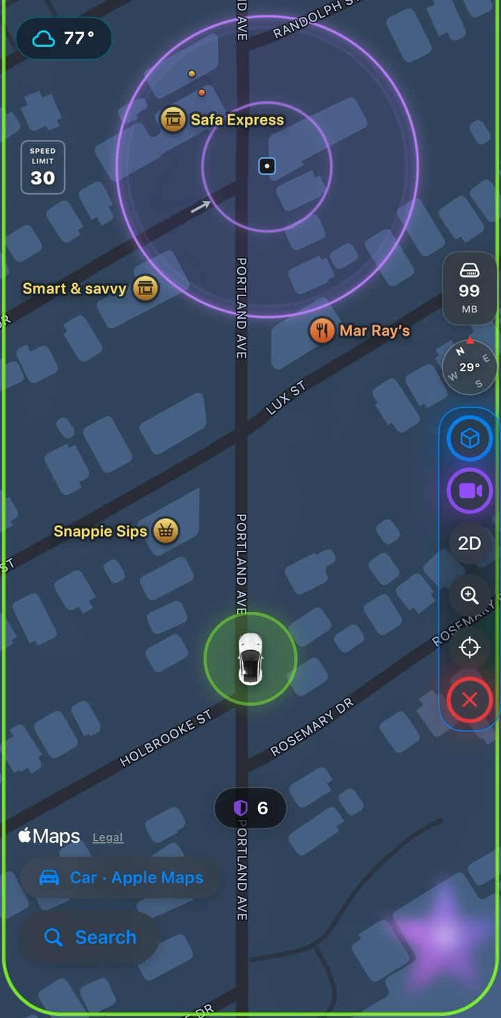
Star Flock GPS puts the public surveillance cameras near you on a live map as you drive. Not just where each one stands, but the ground it actually covers.
Every camera on the map is one somebody recorded in OpenStreetMap. Star Flock GPS does not detect, scan for, or discover cameras itself.
What it looks like on the road
Every mark on the map, and what it is claiming
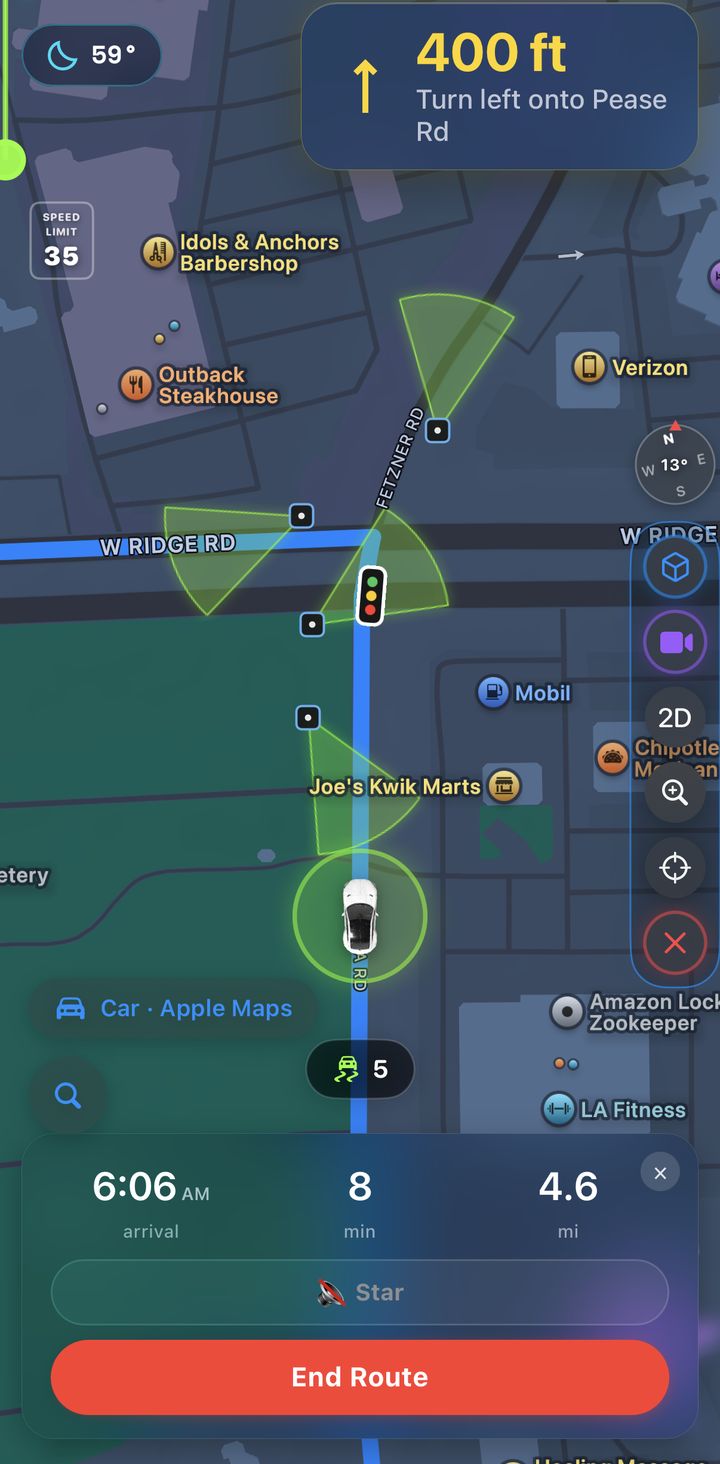
A camera with a heading gets a cone across the ground it covers. A dome camera gets a ring instead — because a cone would have to invent a direction it does not have. The same discipline runs through everything else drawn here.
| Kind | How it is identified | How it is drawn |
|---|---|---|
| Plate reader | surveillance:type=ALPR |
lime cone, radar sweep |
| Police camera | operator names a police department |
lime cone, radar sweep |
| Speed radar | highway=speed_camera |
usually a ring — few are tagged with a heading |
| Other camera | tagged surveillance, kind unclear | lime cone, radar sweep |
| Dome / omnidirectional | no heading tagged at all | pulsing lime ring |
Every camera is the same lime now, whatever kind it is. Colour used to split them — red for police-operated, blue for ordinary CCTV — and that was a claim the tagging cannot support: whether a device is filed as a plate reader, a police camera or plain surveillance depends on who mapped it, so one camera came out a different colour from one town to the next. The SHAPE still carries what is actually known — a cone where a heading is recorded, a ring where none is.
And the places worth reaching
Cameras are things to know about. These are things to get to — so they are drawn by a different rule: the shape says what CATEGORY it is before any colour is read, which still works at night and still works for anyone who does not separate red from green.
| Kind | How it is identified | How it is drawn |
|---|---|---|
| Hospital | amenity=hospital |
pulsing hot pink ring |
| Urgent care | a clinic tagged or named as one | pulsing hot pink ring |
| Veterinary | amenity=veterinary |
pulsing red ring |
| Police station | amenity=police |
pulsing red ring |
| Fire station | amenity=fire_station |
pulsing red ring |
| Airport | aeroway=aerodrome or terminal |
pulsing blue squares |
| Transit station | railway=station, halt,
amenity=bus_station |
pulsing yellow ring |
| Posted item | somebody put it there | gold star, gold stars beating out of it |
| Your destination | the route's end | lime arrow above the door, and a second out on the road aimed at it |
The shape says direction, the colour says kind. A cone means a heading is tagged and a ring means none is — and within that, lime is a plate reader, red a police camera, blue an ordinary one.
Red is kept for emergencies. An airport is not an emergency and neither is a tram stop, so neither is drawn in red — a colour that means everything means nothing, and this is the one colour on a driving map that cannot afford to lose its meaning. Airports get squares rather than rings for the same kind of reason: an airport is grounds with edges, and a circle round a runway would claim a radius it has not got.
The kind is read from the map's own tags and never guessed from where a camera sits. When the tags do not say, it is drawn as "other" rather than sorted into a bucket that would read as a claim.
Built to be read at a glance, not studied
Heading-up, and it follows you
Apple Maps underneath, turned to face the way you are going, framed low so most of the screen is the road ahead. Pan away to look and it returns to you on its own — or tap once to come straight back.
It remembers what it has found
Everything the map turns up stays on it as you explore — cameras, radar and the emergency places alike — rather than fading out behind you. Each sweep asks for roughly a mile around wherever the map is looking, so a thinly mapped suburb still turns up whatever is there. Pan across a city and it fills in and stays filled — and it is kept between launches, so what you found last time is there the next.
A count of what is close
A chip counts the plate readers and police cameras within 800 metres, recounted as you move. At zero it disappears rather than reading "0".
Step through them
Two buttons walk the map to the nearest plate reader or police camera, then the next, nearest first. When there is nothing of that kind in range the button says so by going dim instead of doing nothing.
Tilt when it helps
Flat to see the layout of a junction, tilted to see down the road. The choice is remembered.
Turn-by-turn, with the road ahead marked
Compare routes before you go, then follow the next turn, the speed limit, and the traffic lights and cameras along the way. Take a different road and it re-plots from where you actually are and carries on — the line eases across to the new one rather than cutting, and you are never asked to pick a route again at speed.
An arrow on the door
The destination wears a lime arrow that hovers over the spot and points at it, with the street number above in the speed-limit sign's own numerals so it reads at night. The arrow is glass rather than paint — you can see the doorway underneath the thing pointing at it.
Which side of the road it is on
The destination wears a second arrow, out on the road where the route meets it, aimed across at the door. The first arrow answers "which building"; this one answers the question you actually ask in the last hundred feet. It points at the exact bearing rather than rounding to left or right, and it re-aims as the map turns. When the door is within a few metres of the kerb there is no arrow at all — below that, a side would be invented out of GPS noise rather than shown.
Tap a hospital, and drive to it
Close in, a tap on a hospital, an urgent care or a vet opens a card that says what the place is — an urgent care is walk-in care, not an emergency room, and it says so — with the straight-line distance, labelled as straight-line because the road is longer. Route here hands it to the router and puts you on the drive map with the alternatives drawn and GO under your thumb.
The dashboard, from the wheel
An orb on the map opens the dashboard without leaving the drive, and the dashboard carries the scanner, the radio, the garage and a steering orb back. Things people have posted show up on the road map too, as the same gold star.
Where the hurt are driven, and where help comes from
The places worth knowing the way to, in whatever city you open the map in. The red splits by who the emergency is for: hot pink for hospitals and urgent care — where a person hurt right now is driven TO — and red for police and fire stations, where help is dispatched FROM, with the vet beside them. Those are different errands at two in the morning, and a driver scanning for the first should not have to read four glyphs to find it. Airports stay blue and transit yellow. Each ring is sized to the ground the place occupies rather than a flat radius, so an urgent care in a strip mall no longer rings the road outside it.
How far out the map sits, your choice
Street, Neighborhood, City or State, and it stays there until you pick another — or Automatic, which widens as you speed up and comes back in as you slow. Every camera Star calls pulls the map out for seven seconds so you can see what is around you, then eases back to exactly where it was. On a road lined with cameras it stays out instead: while there are more ahead that have not been called yet, the wide view is held rather than swinging out and back at each one. Pick a height yourself and your choice wins outright.
Drive your own car
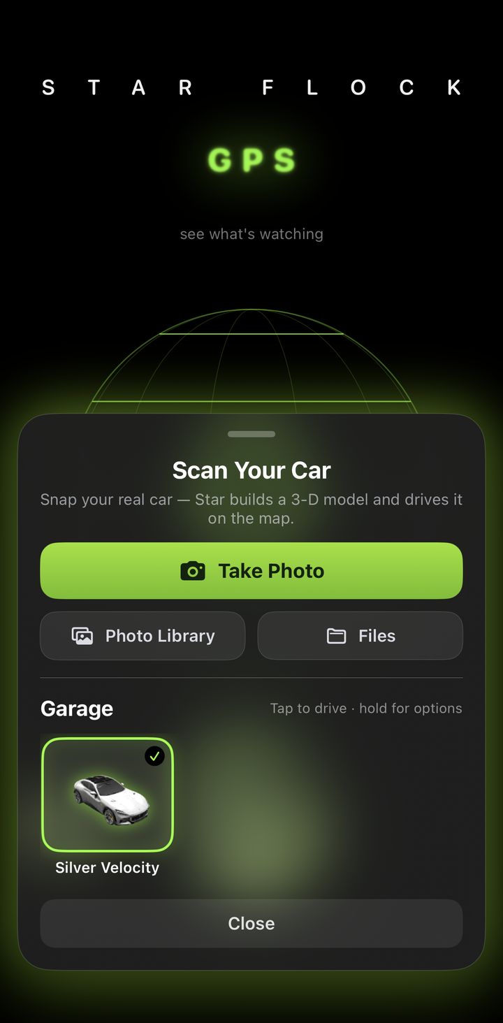
Take a photo of your car and Star Flock GPS builds a 3-D model of it. Keep as many as you like in your garage and switch whenever you want.
How watched each route is, before you pick one
Choose a destination and the alternatives are drawn with their times — and Star counts the cameras along each one as you tap between them: "seven cameras mapped along this route, three of them plate readers." Said while it is still a choice, because after GO it is only news. She says mapped rather than a total on purpose: it counts what has actually been swept, and a route running past where the app has been crosses ground nothing is known about yet.
The extras, and what they cost
The map, turn-by-turn, the camera and radar warnings and Star's voice are free and stay free. The scanner, the radio and scanning your own car sit behind an account: five hours free from the moment you make one, then $4.99 a month for Star Flock GPS, or $12.99 a month for every app. Subscriptions are handled by the App Store.
Star says what is coming
A spoken voice calls the turns the way a car's navigation does — half a mile out, again as you approach, and at the turn itself. The last of those is timed in seconds rather than metres, three seconds from the junction, so the turn is called at motorway speed and not just in town. Coming in, she says which side the destination is on while there is still road to pull over on, then that you have arrived — the whole sentence, not the first half of it.
She also names what is ahead about 500 m before you reach it: a plate reader, a police camera, a speed radar, an ordinary camera. One warning per camera, only for what is in front of you, and a cluster on one junction is one sentence rather than four. Each kind has several phrasings she rotates through, because a sentence repeated every few minutes stops being heard — and a warning that has become wallpaper is worse than none. Voice on / off sits on the card, above GO.
Police, fire and EMS scanner
Live dispatch audio for the area, from public scanner feeds. The walkie-talkie orb is on the intro and on the map, so it can be reached mid-drive.
Radio while you drive
Ten live stations in one panel, switchable mid-song and remembered between drives. It keeps playing in the background and takes the lock screen controls, and it ducks under Star's voice rather than talking over it.
A dashboard for anywhere, not just here
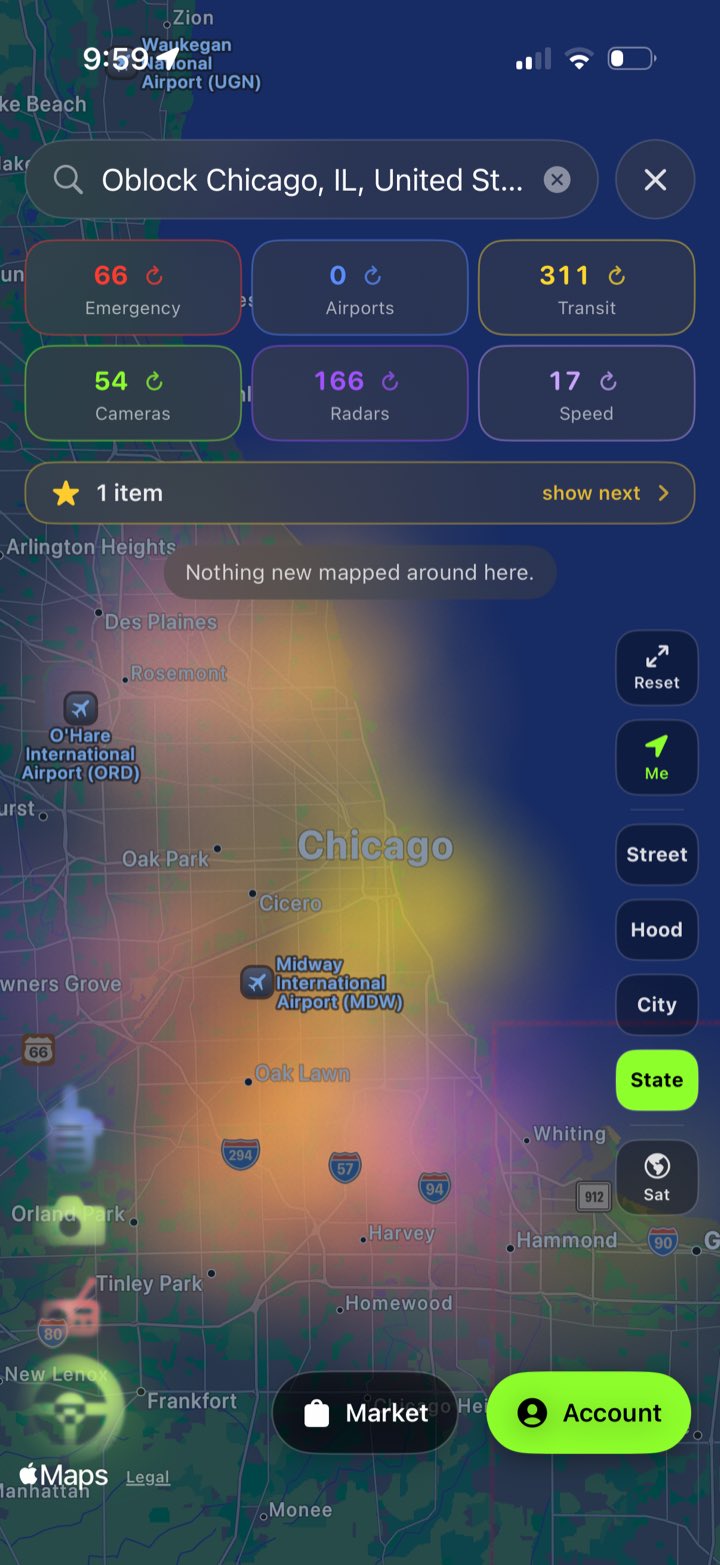
Look up a city you are not in
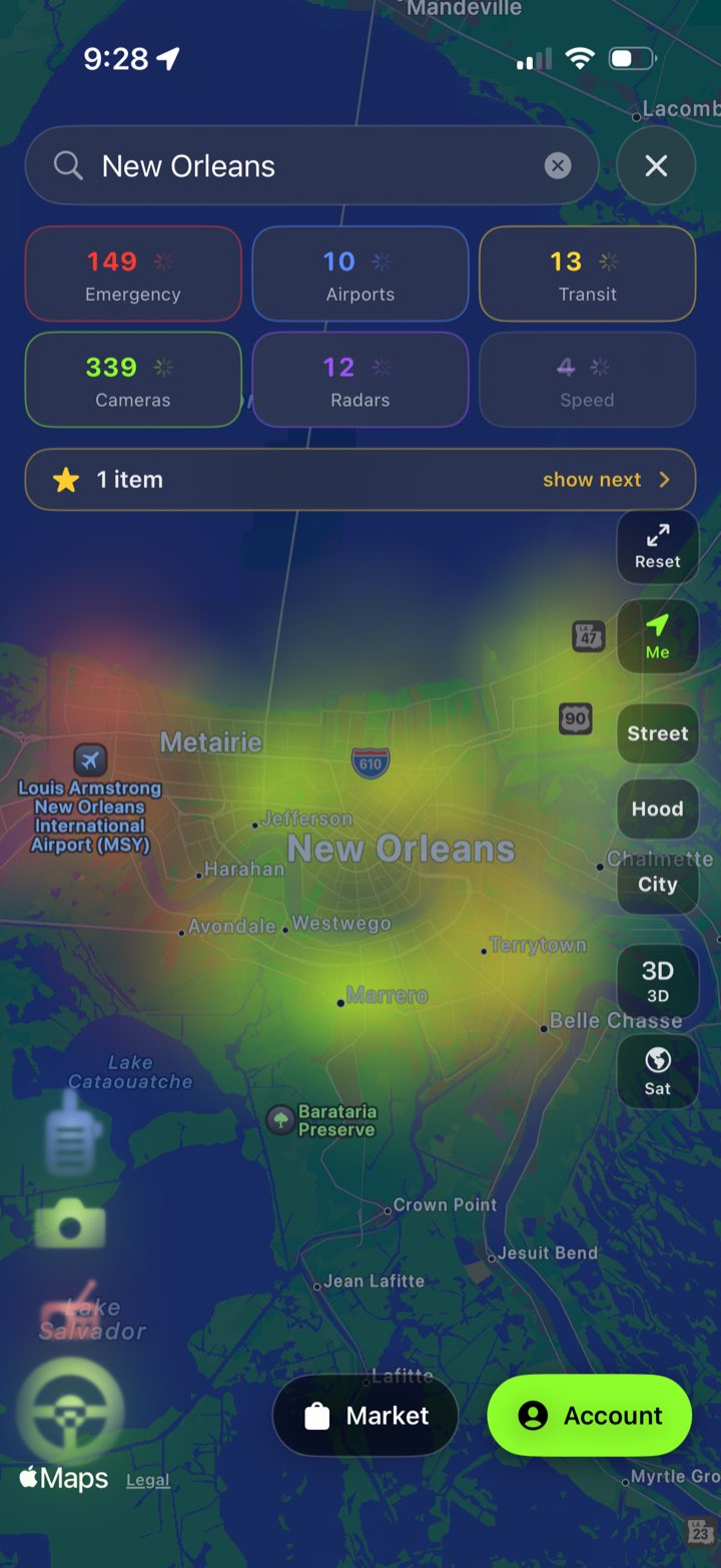
Search a city, town or state and the map goes there and sweeps it — Los Angeles, Miami, wherever. It lands on the place itself at a height you can read, rather than on the middle of a metro area eighty kilometres across.
Seven counts, and each one is a switch
Health, emergency services, airports, transit stations, cameras, radars and speed radar, counted for what is on screen. Health is the hospitals and the urgent cares, split out of the red and counted on their own. Tap a tile to hide that layer; tap the small arrow on it to go and fetch that kind again. The number keeps counting either way — what is out there does not stop being true because it is not being drawn — so a hidden tile is struck through rather than blanked.
Airports and transit
Airports pulse blue in squares rather than rings, because an airport is grounds with edges and a circle would claim a radius it does not have. Train, subway and bus stations pulse yellow. Red stays what it always was — the places you need in an emergency — because a colour that means everything means nothing.
It suggests as you type
Press N and Nashville, Nevada and New York appear, ranked by Apple's own type-ahead. Pick one and the map goes there and sweeps it.
Pull back and it becomes weather
Past the City view the marks stop being marks. Each one softens into fog in its own colour and the fog runs together, so a city reads as where things gather rather than as four hundred things to count. Come back down and every cone, ring and box returns exactly as it was — the two hand over to each other rather than one hiding the other.
Far away, then close up
From above, each camera is a lit box with rings beating out of it. Come down and the box resolves into the thing itself: a sweeping cone where the direction is known, a pulsing ring where it is not.
Street, Hood, City, 3-D and satellite
The same three heights the drive map uses, so the words mean the same thing in both places, plus a tilt into a raked view and a switch to satellite. Your own car sits on the map inside its breathing ring, wherever you are.
Where you have already looked
The last eight places you searched sit under the search bar. Each one remembers the view it landed on, not just the words — so it goes straight back with no lookup, which also means it works with no signal.
It keeps what it found
Everything swept is written to the phone and read back next time, so a city you looked at yesterday draws immediately instead of after a round trip — and draws at all when there is no connection to make one. Public map data only; no record of where you went or when.
Things people want gone, and a way to ask about them
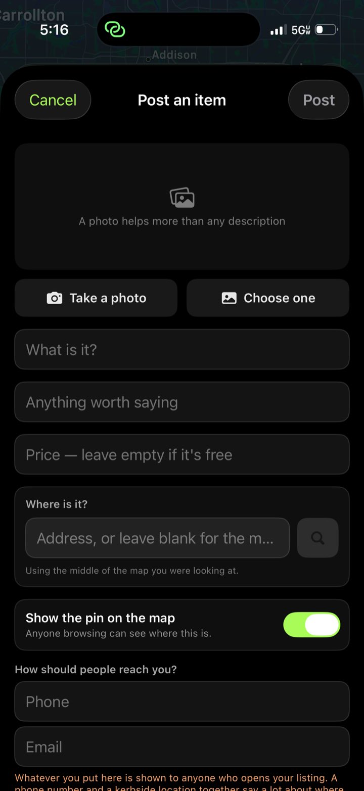
Post what you are done with
A photo, a price — or nothing, which means free — and a place. Type an address or a business name, or leave it and it uses the middle of the map you were looking at; either way the composer says out loud which of the two it is about to use. It shows up as a gold star on both maps, and in a grid you can scroll and search.
Your account, and taking things down
Everything you have posted, in one place, with what it cost, when it expires and a way to delete it — which removes it from everyone else's app too. Listings that have already run out stay listed here rather than vanishing, so you can see what happened to them.
The pin is optional, and that is the point
A kerbside coordinate next to a phone number is close to a home address. Turn the pin off and the listing has no location on any map — the coordinate is not published at all, rather than published and politely ignored. Buyers message you instead, and you say where when you are ready.
Messages, and a sound when one lands
One thread per person per item, so five people asking about the same sofa are five separate conversations — private to the two of you, and enforced by the server rather than by the app being well behaved. When someone writes while you have the app open, the phone makes the same sound it makes for any message and a banner names it.
It clears itself out
Listings and their threads disappear after seven days, swept by whichever phone notices first. A sofa at a kerb is gone in a day or two, and a map of things that are no longer there is worse than an empty one.
Report and block
Anything posted can be reported, and any poster can be blocked so you stop seeing them. Three reports hide a listing from everyone.
What it does not do yet
The account behind a listing is anonymous and lives on this phone — there is no password, so a listing and its threads do not follow you to a new device and cannot be recovered there.
No history, and nothing that says who you are
There are no analytics. Star Flock GPS does not keep a history of where you have been, and nothing it sends carries your name or an identifier. There is a sign-in, and it is optional: skipping it is a button on the same card, and the map, the routing and Star's voice work exactly the same either way. Signing in with Apple, or making an account, saves a name on the phone — there is no Star Flock server for it to go to.
It does have to ask outside services about places. OpenStreetMap for the cameras, traffic lights and speed limits in the area, a routing service for directions, a weather service for the conditions. Those requests describe a location or a route — never who is asking. If you choose to scan your car, that one photo is sent to be turned into a 3-D model, and nothing else goes with it.
Two things are worth stating plainly rather than leaving to the policy page. Star's voice is spoken by Google's Gemini, so each line she says — "in a quarter mile, turn left onto Lee Rd" — is sent there to be turned into audio, street name and all. Turn the voice off and nothing is sent; if Gemini cannot be reached, the iPhone's own voice speaks it instead, on the device. The radio and the scanner play from the stations' own servers, which see the connection the way any streaming app's would.
The marketplace is the exception to all of the above, and it is a real one. Posting an item shares what you typed, the photo you chose, and — unless you turn the pin off — where you put it, along with a random id that stands for your phone. That id is not your name and is tied to nothing about you, but it is an identifier, and everything above about carrying none of them describes the map, not the marketplace.
Messages between buyers and sellers are private. This paragraph used to say the opposite, and it is kept rather than deleted so the change is visible. Each person now has their own mailbox on the database, and the rules only let that person read it — checked on the server, not asked politely of the app. A sender cannot be forged either: a message is refused unless the account writing it is the account it claims to be from. Threads are deleted after seven days.
The account behind that is anonymous. Star Flock signs in without an email address or a password — it gets an identifier the database can verify and nothing else, because the point was to protect the messages, not to start collecting people. The cost is that the account lives on this phone: with no password there is nothing to sign in with elsewhere, so deleting the app loses those threads and the ability to take down those listings.
Location permission is While Using the App only. There is no background behaviour to justify anything more. Full privacy policy →
An Android version is being built
Star Flock GPS is being written a second time for Android — not wrapped, not a web page in a shell. The overlays are the part people recognise, so they are ported drawing by drawing: the same sweeping cone, the same ring beating out of a dome camera, the same fog a city turns into when you pull back, the same car in the same lime ring. The map underneath is OpenStreetMap's rather than Apple's, so the two will never be pixel-identical — but everything drawn over it is.
Star speaks there too. The turn-by-turn, the camera warnings and the count of what is watching each route are the same words in the same order; the voice is the phone's own rather than a network one, which costs nothing and works with no signal.
No date yet, and no sign-up list. It runs today on a test device with the map, the dashboard, the voice, the radio and the scanner working — but shipping is a different bar than running, and this page will say so when it is met rather than before.
What this is not
It is not a complete record. The data is contributed by volunteers, so coverage is excellent in some cities and thin in others. An empty map means nobody has mapped that area — never that there are no cameras in it. The gap is wider than it sounds: a three-kilometre circle over one American city centre holds over a hundred mapped cameras, while the same circle over a suburb a few miles away holds four.
It is not a detector. Star Flock GPS reads a public database. It does not scan, sense or identify anything in the world around you.
It is not a driving aid. Watch the road. Everything on the screen is reference, not instruction.